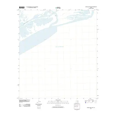
2010 Map of Cedar Lakes East
USGS Topo · Published 2010About this map
Ducroz Cemetery stands as a small landmark of local history on the banks of the San Bernard River, where the river meets the marshy coastal landscape of the Texas Gulf coast. This 2010 survey illustrates a complex hydraulic environment defined by the Intracoastal Waterway cutting through a network of shallow basins including Cedar Lakes and Cowtrap Lakes. The area is characterized by low-lying wetlands and tidal flats that separate the inland waterways from the open Gulf of Mexico. Infrastructure is sparse in this coastal reach, represented primarily by FM 2918 Rd and Bernard River Rd, which provide access to the riverbanks. The map documents the shifting interface of freshwater and saltwater systems at a time when preserving these estuaries was of increasing environmental focus.
Find a feature on this map
8 named features on this map. Tap any name to fly to it.
Don’t see what you’re looking for? This feature index may not catch every label — zoom into the map to look around manually.
Map Details
Editions of this 2010 Cedar Lakes East Map
This is the sole edition of this map. No revisions or reprints were ever made.
Other maps of this area

1943 · Jones Creek
USGS Topo · 1:31,680

1943 · Freeport
USGS Topo · 1:31,680

1943 · Cedar Lakes East
USGS Topo · 1:24,000

1951 · Bay City
USGS Topo · 1:250,000

1952 · Cedar Lane NE
USGS Topo · 1:24,000

1952 · Cedar Lakes West
USGS Topo · 1:24,000

1956 · Bay City
USGS Topo · 1:250,000

1958 · Bay City
USGS Topo · 1:250,000
1963 · Jones Creek
USGS Topo · 1:24,000
1964 · Freeport
USGS Topo · 1:24,000