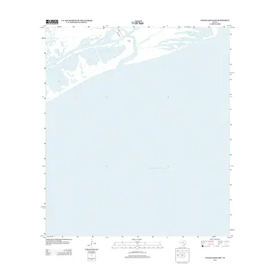
2013 Map of Cedar Lakes East
USGS Topo · Published 2013About this map
The San Bernard River meets the Texas coast in this 2013 survey, where it flows past the Old Intracoastal Waterway before reaching the Gulf of Mexico. The landscape is dominated by complex estuarine systems, most notably the Cowtrap Lakes and Cedar Lakes. These shallow, brackish bodies of water represent a transitional environment where inland freshwater drainage mingles with coastal tides. Local history is anchored by the Ducroz Cem, located just north of the river's bend, providing a specific point of reference for genealogists tracking family ties to this corner of Brazoria County. Infrastructure is limited to rural routes like FM 2918 RD and Co RD 307, reflecting the area's preservation as a maritime and ecological corridor rather than a residential hub.
Find a feature on this map
8 named features on this map. Tap any name to fly to it.
Don’t see what you’re looking for? This feature index may not catch every label — zoom into the map to look around manually.
Map Details
Editions of this 2013 Cedar Lakes East Map
This is the sole edition of this map. No revisions or reprints were ever made.
Other maps of this area

1943 · Jones Creek
USGS Topo · 1:31,680

1943 · Freeport
USGS Topo · 1:31,680

1943 · Cedar Lakes East
USGS Topo · 1:24,000

1951 · Bay City
USGS Topo · 1:250,000

1952 · Cedar Lane NE
USGS Topo · 1:24,000

1952 · Cedar Lakes West
USGS Topo · 1:24,000

1956 · Bay City
USGS Topo · 1:250,000

1958 · Bay City
USGS Topo · 1:250,000
1963 · Jones Creek
USGS Topo · 1:24,000
1964 · Freeport
USGS Topo · 1:24,000