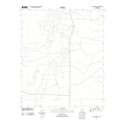
2010 Map of Cedar Point SE
USGS Topo · Published 2010About this map
Mescalero Ridge dominates the western topography of this section of Lea County, creating a distinct environmental boundary across the landscape. The area is characterized by low-density ranching activity, evidenced by established landmarks such as Zimmerman Ranch and Medlin Ranch. These operations are connected by a grid of rural thoroughfares, including County Rd-153 and Meldin Ranch Rd, which navigate the arid terrain. The mapping reflects the enduring ranching economy of Southeast New Mexico in the early 21st century, where large landholdings are identified by family names. Smaller local routes like Ursula provide further evidence of the local infrastructure serving these isolated homesteads and grazing lands.
Find a feature on this map
9 named features on this map. Tap any name to fly to it.
Don’t see what you’re looking for? This feature index may not catch every label — zoom into the map to look around manually.
Map Details
Editions of this 2010 Cedar Point SE Map
This is the sole edition of this map. No revisions or reprints were ever made.
Other maps of this area

1954 · Hobbs
USGS Topo · 1:250,000

1954 · Brownfield
USGS Topo · 1:250,000

1958 · Brownfield
USGS Topo · 1:250,000

1958 · Hobbs
USGS Topo · 1:250,000

1962 · Brownfield
USGS Topo · 1:250,000
1962 · Buckeye
USGS Topo · 1:62,500
1963 · Maljamar
USGS Topo · 1:62,500
1973 · Cedar Point
USGS Topo · 1:24,000
1973 · Caudill Ranch
USGS Topo · 1:24,000
1973 · Cooper-Good Ranch
USGS Topo · 1:24,000