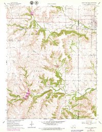
1962 Map of Cedar Vale West
USGS Topo · Published 1979About this map
The Old Indian Treaty Boundary cuts through the southern reaches of this landscape in Cowley and Chautauqua Counties, marking a significant historical line in the settlement of Kansas. The town of Cedar Vale sits along the eastern edge, served by the Missouri Pacific railroad which follows the winding course of Cedar Creek. Further west, the small settlement of Taussig is situated near the confluence of South Cedar Creek and North Cedar Creek. The presence of a Tank Farm, several Oil Wells, and local Quarries indicates a diversified resource-based economy in the early 1960s. For genealogists and local historians, the map preserves the locations of rural burials at Cedar Creek Cem and Rock Creek Cem, alongside distinctively named watercourses like Whar-der-by Creek and Dog Run.
Find a feature on this map
33 named features on this map. Tap any name to fly to it.
Don’t see what you’re looking for? This feature index may not catch every label — zoom into the map to look around manually.
Map Details
Editions of this 1962 Cedar Vale West Map
2 editions found
Other maps of this area

1885 · Sedan
USGS Topo · 1:125,000

1889 · Burden
USGS Topo · 1:125,000

1889 · Sedan
USGS Topo · 1:125,000

1909 · Pawhuska
USGS Topo · 1:125,000

1910 · Pawhuska
USGS Topo · 1:125,000

1916 · Foraker
USGS Topo · 1:62,500

1955 · Wichita
USGS Topo · 1:250,000

1955 · Enid
USGS Topo · 1:250,000

1958 · Enid
USGS Topo · 1:250,000

1958 · Wichita
USGS Topo · 1:250,000