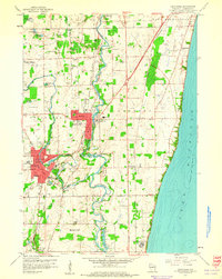
1959 Map of Cedarburg
USGS Topo · Published 1960About this map
The Milwaukee River meanders through the heart of Ozaukee County, anchoring a landscape defined by its transition from agricultural rurality to suburban development in the late 1950s. The industrial and residential cores of Grafton and Cedarburg show significant expansion, with many city streets such as Western Ave and Zur Ruhe Ave clearly delineated. Local history and genealogy are well-represented by numerous schools like Hacker Sch and Pleasant Valley Sch, alongside distinctive burial grounds including Old Settlers Rest Cem and Woodlawn Cem. Along the eastern edge, the high bluffs overlooking Lake Michigan feature small settlements like Ulao, while the interior landscape is dotted with specialized sites ranging from a Drive-in Theater and Grob Landing Field to the specialized Cedarburg Bog. This period captured the rail-heavy transport network of the Chicago and North Western and the Chicago Milwaukee St Paul and Pacific railroads before the era of modern interstate dominance.
Find a feature on this map
54 named features on this map. Tap any name to fly to it.
Don’t see what you’re looking for? This feature index may not catch every label — zoom into the map to look around manually.
Map Details
Editions of this 1959 Cedarburg Map
4 editions found
Other maps of this area

1892 · Milwaukee
USGS Topo · 1:62,500

1892 · Waukesha
USGS Topo · 1:62,500

1892 · Port Washington
USGS Topo · 1:62,500

1901 · Milwaukee
USGS Topo · 1:62,500

1901 · Waukesha
USGS Topo · 1:62,500

1904 · West Bend
USGS Topo · 1:62,500

1904 · Port Washington
USGS Topo · 1:62,500

1906 · Waukesha
USGS Topo · 1:62,500

1906 · Milwaukee
USGS Topo · 1:62,500

1954 · Milwaukee
USGS Topo · 1:250,000