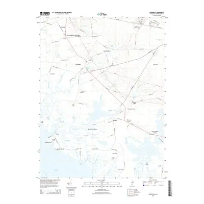
2014 Map of Cedarville
USGS Topo · Published 2014About this map
Cedarville stands as a central hub in this coastal landscape, where the agricultural interior meets the complex marshes of the Delaware Bay. The geography is defined by a dense network of tidal guts and creeks, such as Rattlesnake Gut and Nantuxent Creek, which carve through low-lying areas like The Glades. Local history is anchored by sites like the Old Stone Church Cem near New England Crossroads and the Cedar Hill Cem, while the industrial past is visible at Shaws Mill and Shaws Mill Pond. Small waterfront settlements including Gandys Beach and Money Island illustrate the long-standing connection between the community and the bay. This map reveals a transition from inland forests and lakes, like Lummis Lakes, to the expansive salt marshes and points such as Nantuxent Point and Bradford Point.
Find a feature on this map
121 named features on this map. Tap any name to fly to it.
Don’t see what you’re looking for? This feature index may not catch every label — zoom into the map to look around manually.
Map Details
Editions of this 2014 Cedarville Map
This is the sole edition of this map. No revisions or reprints were ever made.
Other maps of this area

1890 · Maurice Cove
USGS Topo · 1:62,500

1890 · Bay Side
USGS Topo · 1:62,500

1890 · Bridgeton
USGS Topo · 1:62,500

1891 · Maurice Cove
USGS Topo · 1:62,500

1894 · Bay Side
USGS Topo · 1:62,500

1894 · Bridgeton
USGS Topo · 1:62,500

1899 · Vineland
USGS Topo · 1:125,000

1919 · Vineland
USGS Topo · 1:125,000
1931 · Bay Side
USGS Topo · 1:62,500

1934 · Bowers
USGS Topo · 1:48,000
Featured Places
- Fairfield Township, NJ
- Lawrence Township, NJ
- Downe Township, NJ
- Watsons Corner, Downe Township
- Cedarville, Lawrence Township