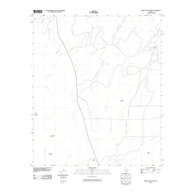
2010 Map of Cement Mountain
USGS Topo · Published 2010About this map
The Colorado River winds through the northern reaches of this West Texas landscape, shaping a terrain defined by limestone heights and intermittent drainage systems. Prominent landmarks such as Cement Mountain and Butterfield Peak rise above the surrounding plains, while Liveoak Ridge and Nipple Peak provide additional topographic orientation. The presence of the Wendland Oil Field in the northeast quadrant highlights the region's petroleum-based economy, a common feature in this part of Coke County. A network of rural routes, including Adams RD P and Valley View RD, connects these elevations, while numerous seasonal waterways like Storey Creek, Jack Miles Creek, and Cobb Creek crisscross the basin. This survey documents the intersection of natural geologic features and modern resource extraction during the early twenty-first century.
Find a feature on this map
28 named features on this map. Tap any name to fly to it.
Don’t see what you’re looking for? This feature index may not catch every label — zoom into the map to look around manually.
Map Details
Editions of this 2010 Cement Mountain Map
This is the sole edition of this map. No revisions or reprints were ever made.
Other maps of this area

1891 · Hayrick
USGS Topo · 1:125,000

1894 · Hayrick
USGS Topo · 1:125,000

1921 · Bronte
USGS Topo · 1:31,680

1921 · Mays School
USGS Topo · 1:31,680

1954 · San Angelo
USGS Topo · 1:250,000

1957 · Carlsbad
USGS Topo · 1:62,500

1957 · Harriet
USGS Topo · 1:62,500

1958 · San Angelo
USGS Topo · 1:250,000
1961 · Shawville
USGS Topo · 1:24,000
1961 · Bronte
USGS Topo · 1:24,000