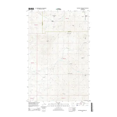
2014 Map of Centennial Mountain
USGS Topo · Published 2014About this map
Saint Pierre sits at the northern edge of this high-elevation landscape where the Bears Paw Mountains rise above the surrounding plains. The terrain is defined by a series of prominent high points and complex drainages, including the height of Centennial Mtn and the distinctively named Oosahquapahmoo Ridge. The map detail shows how early transportation and local industry followed the natural contours of the land, with Coal Mine Rd cutting across the western slopes near Green Cr. Cattle and ranching infrastructure are implied by the network of remote tracks like Duck Creek Rd and Muddy Creek Rd. To the east, the Parker School stands near the head of Parker Canyon, serving the isolated homesteads of this remote stretch of the Hill and Chouteau County line.
Find a feature on this map
44 named features on this map. Tap any name to fly to it.
Don’t see what you’re looking for? This feature index may not catch every label — zoom into the map to look around manually.
Map Details
Editions of this 2014 Centennial Mountain Map
This is the sole edition of this map. No revisions or reprints were ever made.
Other maps of this area

1953 · Havre
USGS Topo · 1:250,000

1957 · Havre
USGS Topo · 1:250,000

1958 · Havre
USGS Topo · 1:250,000

1959 · Warrick
USGS Topo · 1:62,500

1959 · Laredo
USGS Topo · 1:62,500

1959 · Centennial Mountain
USGS Topo · 1:62,500

1959 · Shambo
USGS Topo · 1:62,500
1984 · Bearpaw Lake
USGS Topo · 1:24,000
1984 · Bowery Peak
USGS Topo · 1:24,000
1984 · Centennial Mountain
USGS Topo · 1:24,000