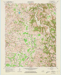
1961 Map of Center
USGS Topo · Published 1973About this map
The Little Barren River carves a winding path through the heart of Kentucky's Green, Hart, and Metcalfe counties, defining a landscape of sharp bends and deep hollows. This 1961 revision documents a rural agrarian network centered around small crossroads settlements like Center, Monroe, and Crailhope. The map reveals a dense concentration of family history markers, with dozens of named burial grounds such as Dishman Cem, McDonald Cem, and Hedgespeth Cem scattered across the uplands.
Find a feature on this map
64 named features on this map. Tap any name to fly to it.
Don’t see what you’re looking for? This feature index may not catch every label — zoom into the map to look around manually.
Map Details
Editions of this 1961 Center Map
4 editions found
Other maps of this area

1934 · Munfordville
USGS Topo · 1:48,000

1935 · Horse Cave
USGS Topo · 1:48,000

1937 · Munfordville
USGS Topo · 1:62,500

1938 · Horse Cave
USGS Topo · 1:62,500

1953 · Sulphur Well
USGS Topo · 1:24,000

1953 · Hudgins
USGS Topo · 1:24,000

1953 · Summersville
USGS Topo · 1:24,000

1953 · Exie
USGS Topo · 1:24,000

1953 · Center
USGS Topo · 1:24,000

1953 · East Fork
USGS Topo · 1:24,000