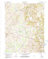
1961 Map of Center
USGS Topo · Published 1991About this map
The Little Barren River meanders sharply through this rural landscape on the border of Hart, Green, and Metcalfe Counties, creating distinctive geological features like Horseshoe Bend. The settlement pattern centers on small crossroads communities and rural institutions, including Center, Whickerville, and Crailhope. A high concentration of family cemeteries and country churches, such as Allens Grove Ch and Shady Grove Ch, underscores the deep genealogical roots of the region. The map also documents the mid-century infrastructure of the area, featuring pipelines traversing the northern terrain and scattered gas wells near Fancher. Prominent landmarks like Pilot Knob provide topographic orientation amidst a network of small waterways including Mouser Branch and Greasy Creek.
Find a feature on this map
64 named features on this map. Tap any name to fly to it.
Don’t see what you’re looking for? This feature index may not catch every label — zoom into the map to look around manually.
Map Details
Editions of this 1961 Center Map
4 editions found
Other maps of this area

1934 · Munfordville
USGS Topo · 1:48,000

1935 · Horse Cave
USGS Topo · 1:48,000

1937 · Munfordville
USGS Topo · 1:62,500

1938 · Horse Cave
USGS Topo · 1:62,500

1953 · Sulphur Well
USGS Topo · 1:24,000

1953 · Hudgins
USGS Topo · 1:24,000

1953 · Summersville
USGS Topo · 1:24,000

1953 · Exie
USGS Topo · 1:24,000

1953 · Center
USGS Topo · 1:24,000

1953 · East Fork
USGS Topo · 1:24,000