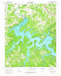
1962 Map of Center Hill Dam
USGS Topo · Published 1964About this map
Center Hill Dam dominates this 1960s landscape, holding back the waters of the Center Hill Reservoir where the Caney Fork and Indian Creek meet. The map reveals the dramatic transformation of the DeKalb County terrain as the winding river valley was submerged to create the sprawling reservoir. Along the intricate shoreline, recreation points like Cove Hollow Dock and Atnip Bluff Cabin Colony appear alongside established landmarks such as the Power Plant.
Find a feature on this map
71 named features on this map. Tap any name to fly to it.
Don’t see what you’re looking for? This feature index may not catch every label — zoom into the map to look around manually.
Map Details
Editions of this 1962 Center Hill Dam Map
4 editions found
Other maps of this area

1893 · Mc Minnville
USGS Topo · 1:125,000

1895 · Mc Minnville
USGS Topo · 1:125,000

1928 · Gordonsville
USGS Topo · 1:62,500

1942 · Statesville
USGS Topo · 1:100,000

1943 · Cookeville
USGS Topo · 1:100,000

1944 · Cookeville
USGS Topo · 1:100,000

1953 · Chattanooga
USGS Topo · 1:250,000

1955 · Baxter
USGS Topo · 1:24,000

1956 · Silver Point
USGS Topo · 1:24,000

1956 · Corbin
USGS Topo · 1:250,000