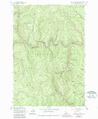
1962 Map of Center Star Mtn
USGS Topo · Published 1987About this map
Mining operations and remote forest terrain define this landscape within the Nez Perce National Forest, as documented in 1962 and later photorevised. The South Fork Clearwater River cuts through the center of the sheet, where evidence of resource extraction is visible in the form of extensive Dredge Tailings near the Gaging Station. A significant concentration of high-elevation prospects and workings is scattered throughout the mountains, including the Center Star Mine located on the slopes of Center Star Mountain. Local history and geology enthusiasts can trace the locations of numerous lode and placer operations such as the Black Lady Mine, Lucky Strike Mine, and the Coeur d'Alene Mine. Recreational developments are also noted along the Crooked River, including the Crooked River No 3 Campground, illustrating the transition of these public lands toward modern forestry and leisure use.
Find a feature on this map
41 named features on this map. Tap any name to fly to it.
Don’t see what you’re looking for? This feature index may not catch every label — zoom into the map to look around manually.
Map Details
Editions of this 1962 Center Star Mtn Map
4 editions found
Other maps of this area

1931 · Buffalo Hump
USGS Topo · 1:125,000

1934 · Buffalo Hump
USGS Topo · 1:125,000

1956 · Elk City
USGS Topo · 1:250,000

1960 · Elk City
USGS Topo · 1:250,000

1962 · Golden
USGS Topo · 1:24,000

1962 · Center Star Mtn
USGS Topo · 1:24,000

1962 · Iron Mtn
USGS Topo · 1:24,000

1962 · Pilot Knob
USGS Topo · 1:24,000

1966 · Elk City
USGS Topo · 1:24,000

1966 · Lick Point
USGS Topo · 1:24,000