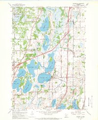
1967 Map of Centerville
USGS Topo · Published 1969About this map
Centerville and the surrounding lake country of Anoka and Washington Counties are defined by a complex aquatic landscape and mid-century institutional development. The village of Centerville sits at a narrow point between Centerville Lake and Peltier Lake, where a Pumping Station and Flowing Wells indicate the local importance of water management. To the west, the sprawling Lino Lakes area is home to the State Correction Center and a Seaplane Base on the western shore of Rice Lake.
Find a feature on this map
49 named features on this map. Tap any name to fly to it.
Don’t see what you’re looking for? This feature index may not catch every label — zoom into the map to look around manually.
Map Details
Editions of this 1967 Centerville Map
4 editions found
Other maps of this area

1902 · White Bear
USGS Topo · 1:62,500

1948 · Stillwater
USGS Topo · 1:62,500

1949 · Stillwater
USGS Topo · 1:62,500

1951 · White Bear Lake East
USGS Topo · 1:24,000

1952 · Centerville
USGS Topo · 1:24,000

1952 · White Bear Lake West
USGS Topo · 1:24,000

1952 · New Brighton
USGS Topo · 1:24,000

1953 · Stillwater
USGS Topo · 1:250,000

1954 · Hugo
USGS Topo · 1:24,000

1955 · Circle Pines
USGS Topo · 1:24,000