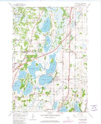
1967 Map of Centerville
USGS Topo · Published 1981About this map
Centerville Lake and the interconnected waters of Peltier Lake form the hydraulic heart of this Anoka County region during the late 1960s and 1970s. The landscape is defined by its transition from agricultural and conservation lands, such as the Carlos Avery State Wildlife Management Area, to the growing suburban structures of Lino Lakes and Hugo. Transportation and infrastructure are prominent, with the Aqueduct and various pipelines traversing the wetlands near Rice Creek. For those tracing local history, the map provides precise locations for the St Genevieve Cem and Twitchel Cem, alongside civic landmarks like the State Correction Center. The presence of a Seaplane Base on Rice Lake highlights the era's active recreational and utilitarian use of the glacial lake chain.
Find a feature on this map
44 named features on this map. Tap any name to fly to it.
Don’t see what you’re looking for? This feature index may not catch every label — zoom into the map to look around manually.
Map Details
Editions of this 1967 Centerville Map
4 editions found
Other maps of this area

1902 · White Bear
USGS Topo · 1:62,500

1948 · Stillwater
USGS Topo · 1:62,500

1949 · Stillwater
USGS Topo · 1:62,500

1951 · White Bear Lake East
USGS Topo · 1:24,000

1952 · Centerville
USGS Topo · 1:24,000

1952 · White Bear Lake West
USGS Topo · 1:24,000

1952 · New Brighton
USGS Topo · 1:24,000

1953 · Stillwater
USGS Topo · 1:250,000

1954 · Hugo
USGS Topo · 1:24,000

1955 · Circle Pines
USGS Topo · 1:24,000