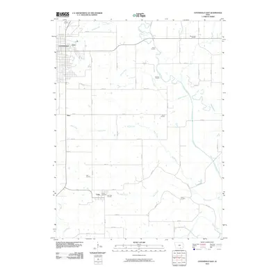
2010 Map of Centerville East
USGS Topo · Published 2010About this map
Centerville anchors the northwestern corner of this landscape, where the street grid of the eastern city limits meets the winding course of Catherall Creek. The terrain is defined by a dense network of waterways, including the broad meanders of the Chariton River and its various tributaries like Hickory Creek and Brush Creek. An interesting hydrological feature is the Old Channel, indicating shifts in the river's path over time.
Find a feature on this map
52 named features on this map. Tap any name to fly to it.
Don’t see what you’re looking for? This feature index may not catch every label — zoom into the map to look around manually.
Map Details
Editions of this 2010 Centerville East Map
This is the sole edition of this map. No revisions or reprints were ever made.
Other maps of this area

1939 · Centerville
USGS Topo · 1:62,500

1939 · Mystic
USGS Topo · 1:62,500

1941 · Centerville
USGS Topo · 1:62,500

1942 · Mystic
USGS Topo · 1:62,500

1954 · Centerville
USGS Topo · 1:250,000

1957 · Centerville
USGS Topo · 1:250,000

1958 · Centerville
USGS Topo · 1:250,000

1966 · Hiattsville
USGS Topo · 1:24,000
1966 · Mystic
USGS Topo · 1:24,000

1968 · Unionville
USGS Topo · 1:24,000