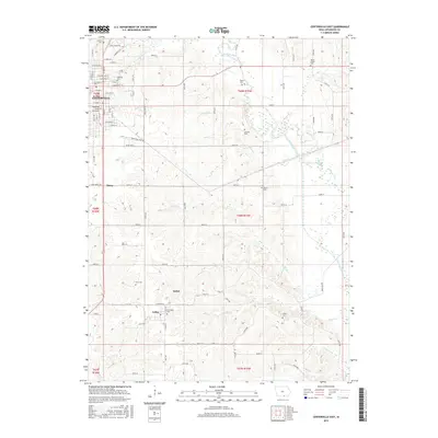
2015 Map of Centerville East
USGS Topo · Published 2015About this map
Centerville serves as the primary urban hub in this southeastern Iowa landscape, where the street grid transitions into the sprawling rural topography of Appanoose County. The Chariton River meanders across the eastern half of the map, notably showing an Old Channel that indicates the waterway's natural shifts over time. This 2015 survey is particularly valuable for genealogical research, documenting numerous rural burial sites including the Jewish Cem, Oakland Cem, and Mount Ararat Cem. The small settlements of Exline, Sedan, and Thirty mark the intersections of county roads and historical rail corridors, while the southern reach is defined by the winding paths of Pigeon Cr and Shoal Cr. The map's detailed documentation of industrial zones and overpasses like the Sixteenth Street Overpass reflects the modern infrastructure supporting this agricultural and trade region.
Find a feature on this map
73 named features on this map. Tap any name to fly to it.
Don’t see what you’re looking for? This feature index may not catch every label — zoom into the map to look around manually.
Map Details
Editions of this 2015 Centerville East Map
This is the sole edition of this map. No revisions or reprints were ever made.
Other maps of this area

1939 · Centerville
USGS Topo · 1:62,500

1939 · Mystic
USGS Topo · 1:62,500

1941 · Centerville
USGS Topo · 1:62,500

1942 · Mystic
USGS Topo · 1:62,500

1954 · Centerville
USGS Topo · 1:250,000

1957 · Centerville
USGS Topo · 1:250,000

1958 · Centerville
USGS Topo · 1:250,000

1966 · Hiattsville
USGS Topo · 1:24,000
1966 · Mystic
USGS Topo · 1:24,000

1968 · Unionville
USGS Topo · 1:24,000