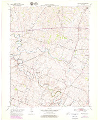
1954 Map of Centerville
USGS Topo · Published 1979About this map
North Elkhorn Creek meanders through the heart of the Bluegrass region, defining a landscape of thoroughbred heritage and rural crossroads. This mid-century documentation shows the transition of the Kentucky countryside just before significant modern developments, featuring the legendary Man O War Monument and the early footprint of the Kentucky State Horse Park. The map illustrates a network of historic turnpikes and rural lanes like Lemons Mill Road and Russell Cave Road, connecting established communities such as Newtown and Centerville.
Find a feature on this map
36 named features on this map. Tap any name to fly to it.
Don’t see what you’re looking for? This feature index may not catch every label — zoom into the map to look around manually.
Map Details
Editions of this 1954 Centerville Map
4 editions found
Other maps of this area

1906 · Georgetown
USGS Topo · 1:62,500

1908 · Georgetown
USGS Topo · 1:62,500

1927 · Lexington
USGS Topo · 1:48,000

1929 · Cynthiana
USGS Topo · 1:48,000

1929 · Lexington
USGS Topo · 1:62,500

1934 · Cynthiana
USGS Topo · 1:62,500

1939 · Sadieville
USGS Topo · 1:62,500

1950 · Lexington East
USGS Topo · 1:24,000

1950 · Lexington West
USGS Topo · 1:24,000

1952 · Clintonville
USGS Topo · 1:24,000