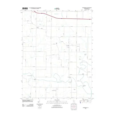
2012 Map of Centerville
USGS Topo · Published 2012About this map
The Little Wabash River and Skillet Fork converge in this corner of White County, defining a landscape shaped by shifting watercourses and industrial extraction. The settlement of Centerville sits at the center of a dense rural grid, surrounded by evidence of the region’s petroleum history, including the Centerville East Oil Field and the Sumpter Oil Field. The terrain is generally low-lying, marked by complex drainage systems like the Schoemann Cutoff and the Randolph Drainage Ditch, though elevations rise slightly at Boyd Hill and the prominent Rattlesnake Bluff along the riverbanks.
Find a feature on this map
72 named features on this map. Tap any name to fly to it.
Don’t see what you’re looking for? This feature index may not catch every label — zoom into the map to look around manually.
Map Details
Editions of this 2012 Centerville Map
This is the sole edition of this map. No revisions or reprints were ever made.
Other maps of this area

1940 · Carmi
USGS Topo · 1:62,500

1941 · Enfield
USGS Topo · 1:62,500

1943 · Carmi
USGS Topo · 1:62,500

1943 · Albion
USGS Topo · 1:62,500

1944 · Enfield
USGS Topo · 1:62,500

1946 · Albion
USGS Topo · 1:62,500

1948 · Fairfield
USGS Topo · 1:62,500

1958 · Belleville
USGS Topo · 1:250,000
1959 · Maunie
USGS Topo · 1:24,000

1962 · Belleville
USGS Topo · 1:250,000