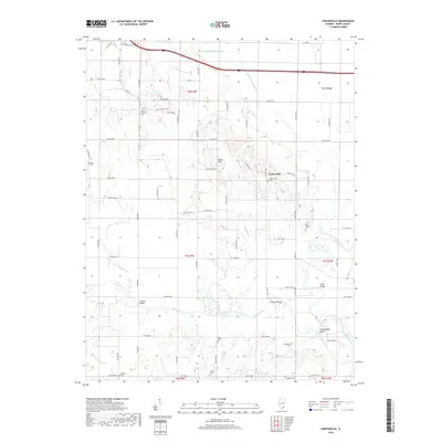
2018 Map of Centerville
USGS Topo · Published 2018About this map
The low-lying bottomlands of White County define this portion of southern Illinois, where the Little Wabash River and Skillet Fork converge. The small settlement of Centerville stands as the primary hub, surrounded by a landscape heavily modified by drainage infrastructure such as the Woods Drainage Ditch, Randolph Drainage Ditch, and the Schoemann Cutoff. These engineering efforts reflect the area's agricultural history, reclaiming fertile ground from the river's floodplains. Genealogists will find a high density of rural burial sites, including the Ralls Family Cem, Old Bethel Cem, and Rebstock Cem, which are scattered among the section lines. Notable crossings like Sumpter Bridge and Winters Bridge span the winding waterways, while local elevation changes are marked by Boyd Hill and the appropriately named Rattlesnake Bluff near the river's edge.
Find a feature on this map
69 named features on this map. Tap any name to fly to it.
Don’t see what you’re looking for? This feature index may not catch every label — zoom into the map to look around manually.
Map Details
Editions of this 2018 Centerville Map
This is the sole edition of this map. No revisions or reprints were ever made.
Other maps of this area

1940 · Carmi
USGS Topo · 1:62,500

1941 · Enfield
USGS Topo · 1:62,500

1943 · Carmi
USGS Topo · 1:62,500

1943 · Albion
USGS Topo · 1:62,500

1944 · Enfield
USGS Topo · 1:62,500

1946 · Albion
USGS Topo · 1:62,500

1948 · Fairfield
USGS Topo · 1:62,500

1958 · Belleville
USGS Topo · 1:250,000
1959 · Maunie
USGS Topo · 1:24,000

1962 · Belleville
USGS Topo · 1:250,000