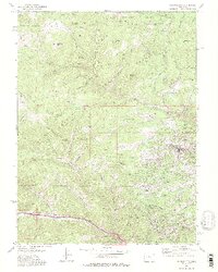
1972 Map of Central City
USGS Topo · Published 1975About this map
Central City and the surrounding mining districts of the Front Range appear here in the early 1970s, showcasing a landscape deeply shaped by a century of extraction. The dense concentration of Mine and Prospects labels surrounding Nevadaville and Black Hawk illustrates the intensity of the gold and silver rush that once defined this region. Settlement patterns follow the narrow drainages of Chase Gulch and Eureka Gulch, where historical mining claims left a legacy of named hills such as Winnebago Hill, Bates Hill, and Gregory Hill.
Find a feature on this map
93 named features on this map. Tap any name to fly to it.
Don’t see what you’re looking for? This feature index may not catch every label — zoom into the map to look around manually.
Map Details
Editions of this 1972 Central City Map
2 editions found
Other maps of this area

1899 · West Denver
USGS Topo · 1:125,000

1903 · Georgetown
USGS Topo · 1:62,500

1905 · Central City
USGS Topo · 1:62,500

1905 · Georgetown
USGS Topo · 1:62,500

1906 · Blackhawk
USGS Topo · 1:62,500

1910 · Central City
USGS Topo · 1:62,500

1912 · Central City
USGS Topo · 1:62,500

1942 · Nederland
USGS Topo · 1:24,000

1942 · Central City
USGS Topo · 1:24,000

1942 · Tungsten
USGS Topo · 1:24,000