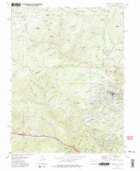
1972 Map of Central City
USGS Topo · Published 1975About this map
Central City and Black Hawk serve as the focal points of this 1972 survey, revealing the dense network of mining infrastructure that defined this section of the Front Range decades after the initial gold rush. The landscape is heavily marked by industrial history, featuring the massive Glory Hole and subterranean works like the Lucania Tunnel. Small settlements and former mining camps such as Nevadaville and Apex are situated among a labyrinth of named gulches and hills, including Maryland Mountain and Winnebago Hill. Genealogy researchers will find significant value in the location of the Russell Gulch Cem and Bald Mountain Cem, which sit alongside numerous active and dormant claims like the Two Forty Mine and Scandia Mine. The transition from industrial extraction to recreation is evident in the presence of the Pickle Gulch Campground and Columbine Campground within the surrounding Arapaho National Forest.
Find a feature on this map
122 named features on this map. Tap any name to fly to it.
Don’t see what you’re looking for? This feature index may not catch every label — zoom into the map to look around manually.
Map Details
Editions of this 1972 Central City Map
2 editions found
Other maps of this area

1899 · West Denver
USGS Topo · 1:125,000

1903 · Georgetown
USGS Topo · 1:62,500

1905 · Central City
USGS Topo · 1:62,500

1905 · Georgetown
USGS Topo · 1:62,500

1906 · Blackhawk
USGS Topo · 1:62,500

1910 · Central City
USGS Topo · 1:62,500

1912 · Central City
USGS Topo · 1:62,500

1942 · Nederland
USGS Topo · 1:24,000

1942 · Central City
USGS Topo · 1:24,000

1942 · Tungsten
USGS Topo · 1:24,000