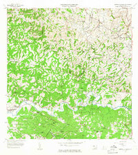
1964 Map of Central La Plata
USGS Topo · Published 1966About this map
The agricultural valleys surrounding the Rio Grande de Añasco and the Rio Culebrinas define this mid-1960s landscape in western Puerto Rico. The dominance of the sugar industry is evident through the central processing hub at Central La Plata and numerous large estates that punctuate the hillsides, including Hacienda Esperanza, Hacienda Morales, and Hacienda Mata. These haciendas represent a distinct era of Puerto Rican land tenure and production prior to the full modernization of the island's interior economy.
Find a feature on this map
95 named features on this map. Tap any name to fly to it.
Don’t see what you’re looking for? This feature index may not catch every label — zoom into the map to look around manually.
Map Details
Editions of this 1964 Central La Plata Map
3 editions found
Other maps of this area

1937 · Aguadilla
USGS Topo · 1:20,000

1937 · Moca
USGS Topo · 1:20,000

1938 · Alto Sano
USGS Topo · 1:20,000

1938 · San Sebastian
USGS Topo · 1:20,000

1938 · Quebradillas
USGS Topo · 1:20,000

1939 · Mayaguez
USGS Topo · 1:30,000

1941 · Moca
USGS Topo · 1:30,000

1941 · Rincon
USGS Topo · 1:30,000

1941 · Rincon
USGS Topo · 1:30,000

1941 · San Sebastian
USGS Topo · 1:30,000
Featured Places
- Sector Serrano, San Sebastián
- Sector La Grúa, Añasco
- Sector Los Crespos, San Sebastián
- Sector Ramos, San Sebastián
- Sector Los Ramos, Moca