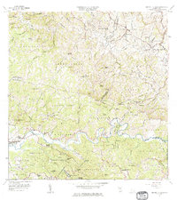
1964 Map of Central La Plata
USGS Topo · Published 1975About this map
The agricultural landscape of northwestern Puerto Rico is defined by the winding course of the Rio Grande de Anasco and the Rio Culebrinas. This 1964 revision reveals a region transitioning from traditional hacienda-based landholding to modern infrastructure, centered around the Central La Plata sugar mill. Family names and local history are etched into the terrain through numerous named estates like Hacienda Esperanza, Hacienda Mata, and Hacienda Morales, which dot the valleys of Rio Arriba and Casey Arriba. The presence of the Antigua Via del Ferrocarril marks the former path of the rail system that once connected these inland agricultural hubs to coastal markets. Higher elevations such as Cerro Gordo and Cerro Pichon overlook a network of rural schools, including Escuela Joaquin Oronoz Rodon and Escuela Las Rosas No 2, serving the dispersed barrios.
Find a feature on this map
110 named features on this map. Tap any name to fly to it.
Don’t see what you’re looking for? This feature index may not catch every label — zoom into the map to look around manually.
Map Details
Editions of this 1964 Central La Plata Map
3 editions found
Other maps of this area

1937 · Aguadilla
USGS Topo · 1:20,000

1937 · Moca
USGS Topo · 1:20,000

1938 · Alto Sano
USGS Topo · 1:20,000

1938 · San Sebastian
USGS Topo · 1:20,000

1938 · Quebradillas
USGS Topo · 1:20,000

1939 · Mayaguez
USGS Topo · 1:30,000

1941 · Moca
USGS Topo · 1:30,000

1941 · Rincon
USGS Topo · 1:30,000

1941 · Rincon
USGS Topo · 1:30,000

1941 · San Sebastian
USGS Topo · 1:30,000
Featured Places
- Sector Serrano, San Sebastián
- Sector La Grúa, Añasco
- Sector Los Crespos, San Sebastián
- Sector Ramos, San Sebastián
- Sector Los Ramos, Moca