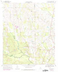
1968 Map of Central Mills
USGS Topo · Published 1984About this map
Central Mills sits at the heart of this survey, where the convergence of Perry and Dallas counties meets the winding path of Chilatchee Creek. The landscape is defined by its rural density, marked by numerous congregations including Shady Grove Ch, Concord Ch, and Pine Grove Ch. These community hubs are connected by a network of unimproved roads and several watercourses such as Little Chilatchee Creek and Rogers Creek.
Find a feature on this map
32 named features on this map. Tap any name to fly to it.
Don’t see what you’re looking for? This feature index may not catch every label — zoom into the map to look around manually.
Map Details
Editions of this 1968 Central Mills Map
3 editions found
Other maps of this area

1953 · Montgomery
USGS Topo · 1:250,000

1956 · Montgomery
USGS Topo · 1:250,000

1957 · Montgomery
USGS Topo · 1:250,000

1968 · Thomaston East
USGS Topo · 1:24,000

1968 · Uniontown West
USGS Topo · 1:24,000

1968 · Uniontown East
USGS Topo · 1:24,000

1968 · Browns
USGS Topo · 1:24,000

1968 · Safford
USGS Topo · 1:24,000

1968 · Central Mills
USGS Topo · 1:24,000

1974 · Crumptonia
USGS Topo · 1:24,000