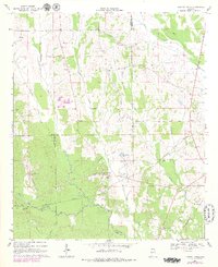
1968 Map of Central Mills
USGS Topo · Published 1979About this map
Chilatchee Creek and its many tributaries, including Little Chilatchee Creek and Rogers Creek, define the topography of this rural Black Belt landscape. The settlement of Central Mills serves as a central point along the Louisville and Nashville railroad corridor, which traverses the area alongside the Southern line. This 1960s survey captures a community deeply rooted in its local institutions, evidenced by the high density of country churches such as Shady Grove Ch, Concord Ch, and New Bethel Spring Ch.
Find a feature on this map
33 named features on this map. Tap any name to fly to it.
Don’t see what you’re looking for? This feature index may not catch every label — zoom into the map to look around manually.
Map Details
Editions of this 1968 Central Mills Map
3 editions found
Other maps of this area

1953 · Montgomery
USGS Topo · 1:250,000

1956 · Montgomery
USGS Topo · 1:250,000

1957 · Montgomery
USGS Topo · 1:250,000

1968 · Thomaston East
USGS Topo · 1:24,000

1968 · Uniontown West
USGS Topo · 1:24,000

1968 · Uniontown East
USGS Topo · 1:24,000

1968 · Browns
USGS Topo · 1:24,000

1968 · Safford
USGS Topo · 1:24,000

1968 · Central Mills
USGS Topo · 1:24,000

1974 · Crumptonia
USGS Topo · 1:24,000