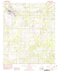
1982 Map of Sardis
USGS Topo · Published 1982About this map
The Alabama River winds across the northern edge of this Dallas County landscape, defining the geographic orientation for local river-front settlements and industry. In the early 1980s, the area near Selmont shows a concentrated mix of infrastructure, including the Cahaba Airport, a Golf Course, and several Trailer Parks near Tarver. The map illustrates a rural economy reliant on natural resources, evidenced by a Sand Pit along the river and various Gravel Pits and Clay Pits scattered near Casey and Sardis. Several small water bodies and drainage systems, such as Hawthorne Lake, Sixmile Creek, and Soapstone Creek, carve through the terrain between the dispersed communities of Polk and Tyler. This provisional survey preserves the location of numerous cemeteries and rural landmarks like the Athletic Fld before later development altered these traditional community footprints.
Find a feature on this map
24 named features on this map. Tap any name to fly to it.
Don’t see what you’re looking for? This feature index may not catch every label — zoom into the map to look around manually.
Map Details
Editions of this 1982 Sardis Map
This is the sole edition of this map. No revisions or reprints were ever made.
Other maps of this area

1953 · Montgomery
USGS Topo · 1:250,000

1956 · Montgomery
USGS Topo · 1:250,000

1957 · Montgomery
USGS Topo · 1:250,000

1957 · Carlowville
USGS Topo · 1:62,500

1957 · Benton
USGS Topo · 1:62,500

1957 · Braggs
USGS Topo · 1:62,500

1958 · Selma
USGS Topo · 1:62,500

1958 · Selma
USGS Topo · 1:24,000

1975 · Benton SE
USGS Topo · 1:24,000

1975 · Selma SE
USGS Topo · 1:24,000