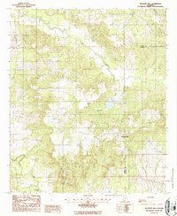
1987 Map of Pleasant Hill
USGS Topo · Published 1987About this map
Pleasant Hill serves as the central community in this rural pocket of the Alabama Black Belt during the late twentieth century. Located near the eastern boundary of Dallas County, the area is defined by a dense network of watercourses and shifting elevations. The drainage systems of Mush Creek, Hurricane Creek, and Cedar Creek carve through the landscape, creating a topography of ridges and bottoms that has historically influenced local land use and property lines.
Find a feature on this map
7 named features on this map. Tap any name to fly to it.
Don’t see what you’re looking for? This feature index may not catch every label — zoom into the map to look around manually.
Map Details
Editions of this 1987 Pleasant Hill Map
This is the sole edition of this map. No revisions or reprints were ever made.
Other maps of this area

1953 · Montgomery
USGS Topo · 1:250,000

1956 · Montgomery
USGS Topo · 1:250,000

1957 · Montgomery
USGS Topo · 1:250,000

1957 · Carlowville
USGS Topo · 1:62,500

1957 · Benton
USGS Topo · 1:62,500

1957 · Braggs
USGS Topo · 1:62,500

1958 · Selma
USGS Topo · 1:62,500

1975 · Benton SE
USGS Topo · 1:24,000

1975 · Selma SE
USGS Topo · 1:24,000

1975 · Carlowville NE
USGS Topo · 1:24,000