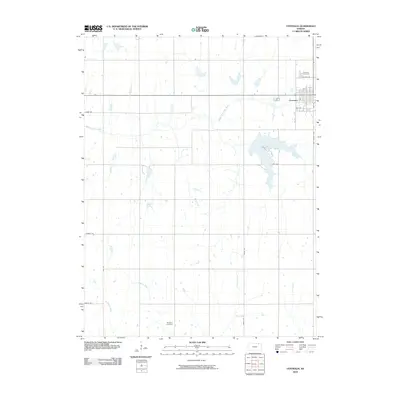
2010 Map of Centralia
USGS Topo · Published 2010About this map
The town of Centralia anchors this section of Nemaha County, defined by a grid of agricultural section lines and a network of wandering waterways. The Black Vermillion River cuts through the northern landscape, while several tributaries including French Creek, Mulberry Creek, and Coal Creek drain the surrounding prairie. This 2010 survey illustrates the enduring rural structure of the region, where family history is anchored at sites like Centralia Cemetery north of the town center and the more isolated Mulberry Cemetery further south. The map details the local infrastructure from the town’s residential streets like Oak St and 6th St to rural connectors such as Old Number Nine and Onaga Rd. A large unnamed reservoir south of Centralia, accessed via Lake Rd, represents a significant modification to the natural drainage of the Black Vermillion River watershed.
Find a feature on this map
21 named features on this map. Tap any name to fly to it.
Don’t see what you’re looking for? This feature index may not catch every label — zoom into the map to look around manually.
Map Details
Editions of this 2010 Centralia Map
This is the sole edition of this map. No revisions or reprints were ever made.
Other maps of this area

1889 · Seneca
USGS Topo · 1:125,000

1894 · Seneca
USGS Topo · 1:125,000

1955 · Manhattan
USGS Topo · 1:250,000

1956 · Manhattan
USGS Topo · 1:250,000

1957 · Manhattan
USGS Topo · 1:250,000

1966 · Baileyville
USGS Topo · 1:24,000

1966 · Axtell
USGS Topo · 1:24,000
1966 · Seneca
USGS Topo · 1:24,000
1969 · Centralia
USGS Topo · 1:24,000
1969 · Havensville
USGS Topo · 1:24,000