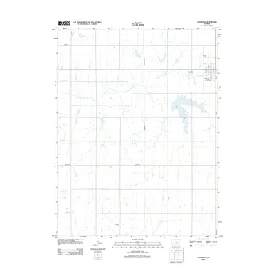
2012 Map of Centralia
USGS Topo · Published 2012About this map
The Black Vermillion River meanders across this rural section of Nemaha County, anchoring a landscape defined by organized agriculture and small-town infrastructure. The settlement of Centralia occupies the northeast corner, where a classic grid of streets like Walnut St and Oak St centers on the local Post Office. This 2012 survey illustrates the enduring spatial layout of the High Plains, where long, straight section-line roads such as Ridge Rd, Utah Rd, and Zenith Rd divide the territory into predictable blocks. Genealogy researchers will find several notable burial sites documented, including Centralia Cem north of the township and the more isolated Mulberry Cem to the south. Numerous small waterways, including Kearney Branch, Gilson Creek, and French Creek, feed into the larger river system, shaping the drainage patterns and low-lying topography of the surrounding farmland.
Find a feature on this map
29 named features on this map. Tap any name to fly to it.
Don’t see what you’re looking for? This feature index may not catch every label — zoom into the map to look around manually.
Map Details
Editions of this 2012 Centralia Map
This is the sole edition of this map. No revisions or reprints were ever made.
Other maps of this area

1889 · Seneca
USGS Topo · 1:125,000

1894 · Seneca
USGS Topo · 1:125,000

1955 · Manhattan
USGS Topo · 1:250,000

1956 · Manhattan
USGS Topo · 1:250,000

1957 · Manhattan
USGS Topo · 1:250,000

1966 · Baileyville
USGS Topo · 1:24,000

1966 · Axtell
USGS Topo · 1:24,000
1966 · Seneca
USGS Topo · 1:24,000
1969 · Centralia
USGS Topo · 1:24,000
1969 · Havensville
USGS Topo · 1:24,000