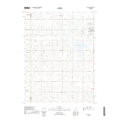
2018 Map of Centralia
USGS Topo · Published 2018About this map
Centralia serves as the primary hub of this eastern Kansas landscape, situated near the headwaters of several drainage systems. The town layout is defined by a grid including Commercial St and Railroad Ave, reflecting its historical reliance on transportation corridors. The surrounding terrain is deeply carved by the Black Vermillion River and its various tributaries, including French Cr and Mulberry Cr. Genealogists will find interest in the documented locations of the Centralia Cem north of the town center and the more isolated Mulberry Cem to the southwest. The map also delineates the boundary between Marshall and Nemaha counties, showing how local roads like Ridge Rd and Sunflower Rd stitch together the rural property lines of these agricultural townships.
Find a feature on this map
39 named features on this map. Tap any name to fly to it.
Don’t see what you’re looking for? This feature index may not catch every label — zoom into the map to look around manually.
Map Details
Editions of this 2018 Centralia Map
This is the sole edition of this map. No revisions or reprints were ever made.
Other maps of this area

1889 · Seneca
USGS Topo · 1:125,000

1894 · Seneca
USGS Topo · 1:125,000

1955 · Manhattan
USGS Topo · 1:250,000

1956 · Manhattan
USGS Topo · 1:250,000

1957 · Manhattan
USGS Topo · 1:250,000

1966 · Baileyville
USGS Topo · 1:24,000

1966 · Axtell
USGS Topo · 1:24,000
1966 · Seneca
USGS Topo · 1:24,000
1969 · Centralia
USGS Topo · 1:24,000
1969 · Havensville
USGS Topo · 1:24,000