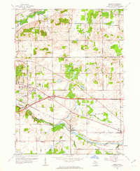
1961 Map of Ceresco
USGS Topo · Published 1962About this map
The Kalamazoo River and the New York Central railroad corridor define the southern landscape of this Calhoun County region in the early 1960s. The settlement of Ceresco sits at a river bend, supported by its namesake Ceresco Cem and nearby Conley Sch. Further west, the growing suburban footprint of Wattles Park is evident, featuring a Drive-in Theater and the expansive Floral Lawn Memorial Gdns.
Find a feature on this map
43 named features on this map. Tap any name to fly to it.
Don’t see what you’re looking for? This feature index may not catch every label — zoom into the map to look around manually.
Map Details
Editions of this 1961 Ceresco Map
3 editions found
Other maps of this area

1918 · Battle Creek
USGS Topo · 1:62,500

1918 · Union City
USGS Topo · 1:62,500

1921 · Marshall
USGS Topo · 1:62,500

1923 · Marshall
USGS Topo · 1:62,500

1943 · Battle Creek
USGS Topo · 1:62,500

1943 · Marshall
USGS Topo · 1:62,500

1947 · Bellevue
USGS Topo · 1:24,000

1947 · Bedford
USGS Topo · 1:24,000

1947 · Ceresco
USGS Topo · 1:24,000

1947 · Battle Creek
USGS Topo · 1:24,000
Featured Places
- Pennfield Charter Township, MI
- Pennfield, MI
- Emmett Charter Township, MI
- Marshall Township, MI
- Ceresco, MI