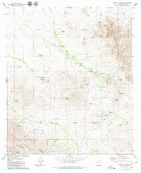
1979 Map of Cerro Colorado
USGS Topo · Published 1979About this map
Mining operations and ranching outposts define this arid landscape in Pima County, captured during a period of active land use in the late 1970s. The Cerro Colorado Mountains and Las Guijas Mountains dominate the terrain, where numerous small-scale mining sites like the Liberty Mine and Silver Hill Mine are scattered across the slopes. Water management is central to survival here, evidenced by a network of catchments such as Rincon Tank and Bolas Blancas Wash, along with an Aqueduct system cutting through the valley floor.
Find a feature on this map
53 named features on this map. Tap any name to fly to it.
Don’t see what you’re looking for? This feature index may not catch every label — zoom into the map to look around manually.
Map Details
Editions of this 1979 Cerro Colorado Map
3 editions found
Other maps of this area

1920 · Arivaca
USGS Topo · 1:125,000

1925 · Samaniego Peak
USGS Topo · 1:62,500

1939 · Twin Buttes
USGS Topo · 1:62,500

1939 · Tubac
USGS Topo · 1:62,500

1940 · Palo Alto Ranch
USGS Topo · 1:62,500

1941 · Twin Buttes
USGS Topo · 1:62,500

1941 · Arivaca
USGS Topo · 1:62,500

1943 · Arivaca
USGS Topo · 1:62,500

1943 · Palo Alto Ranch
USGS Topo · 1:62,500

1943 · Tubac
USGS Topo · 1:62,500