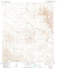
1979 Map of Cerro Colorado
USGS Topo · Published 1985About this map
Mining operations and remote desert outposts dominate this Pima County landscape, reflecting a region defined by mineral exploration in the late 1970s. The Cerro Colorado Mountains and Las Guijas Mountains harbor a dense concentration of historical claims, including the Liberty Mine, Silver Hill Mine, and the Black Princess Mine. The presence of New Colorado Mine and several prospects suggests a persistent interest in the precious metals of the Arizona desert long after the initial booms of the previous century.
Find a feature on this map
49 named features on this map. Tap any name to fly to it.
Don’t see what you’re looking for? This feature index may not catch every label — zoom into the map to look around manually.
Map Details
Editions of this 1979 Cerro Colorado Map
3 editions found
Other maps of this area

1920 · Arivaca
USGS Topo · 1:125,000

1925 · Samaniego Peak
USGS Topo · 1:62,500

1939 · Twin Buttes
USGS Topo · 1:62,500

1939 · Tubac
USGS Topo · 1:62,500

1940 · Palo Alto Ranch
USGS Topo · 1:62,500

1941 · Twin Buttes
USGS Topo · 1:62,500

1941 · Arivaca
USGS Topo · 1:62,500

1943 · Arivaca
USGS Topo · 1:62,500

1943 · Palo Alto Ranch
USGS Topo · 1:62,500

1943 · Tubac
USGS Topo · 1:62,500