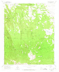
1963 Map of Cerro Pelon
USGS Topo · Published 1974About this map
Cibola National Forest defines the rugged topography of this New Mexico quadrangle, where the high peaks of Cerro Pelon and Cerro Osha overlook a landscape of deep canyons and seasonal water sources. The map captures a transitional zone between the Bartolome Fernandez Grant Boundary and the public lands of McKinley and Valencia counties. The terrain is marked by numerous livestock-related features, including Silt Tank, Effran Tank, and Llanito Frio Tanks, which supported the ranching economy of the mid-20th century. Notable human activity is centered at Fernandez Camp and within the San Mateo Springs Tract No 2. A complex network of springs, such as Sandoval Cabin Spring and Seboyetita Spring, highlights the critical importance of water management in this arid environment, while the waters of Seboyeta Creek and Rio Paguate drain the high country to the south.
Find a feature on this map
56 named features on this map. Tap any name to fly to it.
Don’t see what you’re looking for? This feature index may not catch every label — zoom into the map to look around manually.
Map Details
Editions of this 1963 Cerro Pelon Map
3 editions found
Other maps of this area

1883 · Mt. Taylor
USGS Topo · 1:250,000

1886 · Mt. Taylor
USGS Topo · 1:250,000

1892 · Mt. Taylor
USGS Topo · 1:250,000

1899 · Mt. Taylor
USGS Topo · 1:250,000

1957 · Lobo Springs
USGS Topo · 1:24,000

1957 · Mount Taylor
USGS Topo · 1:24,000

1957 · Seboyeta
USGS Topo · 1:24,000

1958 · Albuquerque
USGS Topo · 1:250,000

1961 · El Dado Mesa
USGS Topo · 1:24,000
1961 · Laguna Canoneros
USGS Topo · 1:24,000