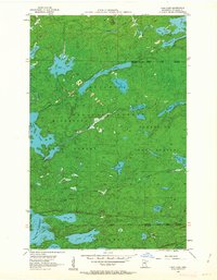
1956 Map of Chad Lake
USGS Topo · Published 1963About this map
The Superior National Forest dominates this mid-century landscape of northern St. Louis County, where a complex network of glacial lakes and waterways defines the wilderness. At the northern edge of the Iron Range, this survey documents a period when the Minnesota State Forest and various administrative boundaries, such as the Burntside State Forest Boundary, managed the expansive timberlands. The hydrography is notably dense, featuring the long reach of Buck Lake and the northern bays of Vermilion Lake, including Rice Bay and Bass Bay. Landmarks like Indian Point and the large Sioux Pine Island stand as significant navigational points for those traveling these waters. The map records the primitive road classifications of the era, showing a landscape largely untouched by heavy development, primarily accessed via unpaved routes and water trails through the dense forest canopy.
Find a feature on this map
30 named features on this map. Tap any name to fly to it.
Don’t see what you’re looking for? This feature index may not catch every label — zoom into the map to look around manually.
Map Details
Editions of this 1956 Chad Lake Map
3 editions found
Other maps of this area

1954 · Hibbing
USGS Topo · 1:250,000

1954 · International Falls
USGS Topo · 1:250,000

1956 · Sioux Pine Island
USGS Topo · 1:24,000

1956 · Tower
USGS Topo · 1:24,000

1956 · Chad Lake
USGS Topo · 1:24,000
1956 · Soudan
USGS Topo · 1:24,000

1956 · Crab Lake
USGS Topo · 1:24,000

1956 · Eagles Nest
USGS Topo · 1:24,000

1957 · Hibbing
USGS Topo · 1:250,000

1957 · International Falls
USGS Topo · 1:250,000
Featured Places
- Northeast St Louis, MN
- Crab Lake, MN
- Eagles Nest Township, MN
- Breitung Township, MN
- Saint Louis County, MN