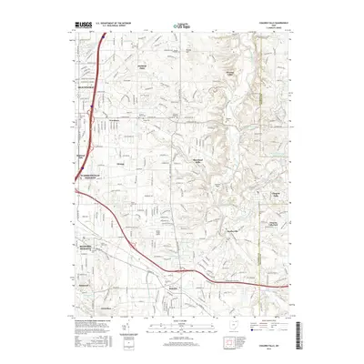
2016 Map of Chagrin Falls
USGS Topo · Published 2016About this map
The Chagrin River corridor defines the eastern edge of this suburban landscape, where the steep topography of Orange Hill and Harper Ridge meets the developed corridors of eastern Cuyahoga County. This survey highlights a unique concentration of local heritage sites, including numerous burial grounds such as the Bet Olam Cem and the Jackson Family Cem. The village of Chagrin Falls sits as a primary anchor, with its industrial and social history tied to the Millpond and nearby Upper Lake. Educational and civic foundations like Ursuline Coll are established alongside affluent residential enclaves in Hunting Valley and Pepper Pike. The mapping shows a complex network of residential roads interwoven with significant water features like Griswold Cr and Tinkers Cr, illustrating the mid-century suburban expansion that transformed the region's agricultural past into a series of interconnected residential communities.
Find a feature on this map
255 named features on this map. Tap any name to fly to it.
Don’t see what you’re looking for? This feature index may not catch every label — zoom into the map to look around manually.
Map Details
Editions of this 2016 Chagrin Falls Map
This is the sole edition of this map. No revisions or reprints were ever made.
Other maps of this area

1901 · Euclid
USGS Topo · 1:62,500

1903 · Cleveland
USGS Topo · 1:62,500

1903 · Euclid
USGS Topo · 1:62,500

1905 · Mentor
USGS Topo · 1:62,500

1906 · Chagrin Falls
USGS Topo · 1:62,500

1907 · Mentor
USGS Topo · 1:62,500

1908 · Chagrin Falls
USGS Topo · 1:62,500

1950 · Cleveland
USGS Topo · 1:250,000

1953 · South Russell
USGS Topo · 1:24,000

1953 · Aurora
USGS Topo · 1:24,000