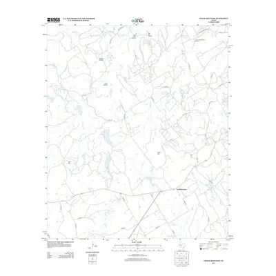
2013 Map of Chalk Mountain
USGS Topo · Published 2013About this map
Chalk Mountain serves as the focal point for this 2013 topographic survey, marking the transition between the watershed of Rough Cr and the upper reaches of the E Bosque River. The landscape is defined by its series of distinct drainage basins and family-named landmarks, such as Big Kid Hollow and Buffalo Hollow, which weave through the terrain. Evidence of local ranching and water management is clear from the numerous small reservoirs like Lesley Lake, Seals Lake, and Shipman Lake. Transportation in this part of Erath County is anchored by the crossing of Highway 67 and Highway 220, while aviation infrastructure is represented by the Circle Eight Ranch Airport to the northeast. Notable elevations include the eponymous Chalk Mtn and the isolated rise of Lone Mtn to the west.
Find a feature on this map
50 named features on this map. Tap any name to fly to it.
Don’t see what you’re looking for? This feature index may not catch every label — zoom into the map to look around manually.
Map Details
Editions of this 2013 Chalk Mountain Map
This is the sole edition of this map. No revisions or reprints were ever made.
Other maps of this area

1889 · Granbury
USGS Topo · 1:125,000

1890 · Stephenville
USGS Topo · 1:125,000

1920 · Stephenville
USGS Topo · 1:125,000

1931 · Tolar
USGS Topo · 1:62,500

1954 · Dallas
USGS Topo · 1:250,000

1954 · Abilene
USGS Topo · 1:250,000

1958 · Dallas
USGS Topo · 1:250,000

1958 · Abilene
USGS Topo · 1:250,000

1961 · Johnsville
USGS Topo · 1:24,000
1961 · Hill City
USGS Topo · 1:24,000