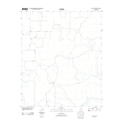
2012 Map of Chalk SW
USGS Topo · Published 2012About this map
The expansive ranching landscape of King County is defined by its intermittent watercourses and the infrastructure of historic cattle operations. JY Ranch West Camp serves as a central point of activity within this territory, illustrating the continued significance of the ranching industry in West Texas during the early 21st century. The terrain is marked by the winding paths of Farrer Cr and Dry Cr, both of which drain toward the Middle Fork Wichita River in the southeastern corner of the quadrangle. Local history is anchored at the Shinnery Cem, a solitary landmark near the intersection of several county roads in the northwest. This network of unpaved paths, such as Co RD-462 and Creek 462, provides access across the open country, connecting isolated ranching outposts to primary routes like Ranch Road 3416.
Find a feature on this map
20 named features on this map. Tap any name to fly to it.
Don’t see what you’re looking for? This feature index may not catch every label — zoom into the map to look around manually.
Map Details
Editions of this 2012 Chalk SW Map
This is the sole edition of this map. No revisions or reprints were ever made.
Other maps of this area

1954 · Lubbock
USGS Topo · 1:250,000

1966 · Ox Yoke Creek
USGS Topo · 1:24,000

1966 · Chalk SW
USGS Topo · 1:24,000

1966 · J Y Ranch
USGS Topo · 1:24,000

1966 · Lowrance Mountain
USGS Topo · 1:24,000

1967 · Fourmile Hill
USGS Topo · 1:24,000

1968 · Y Ranch
USGS Topo · 1:24,000

1968 · Grow
USGS Topo · 1:24,000
1968 · Chalk
USGS Topo · 1:24,000
1968 · Ginsite
USGS Topo · 1:24,000