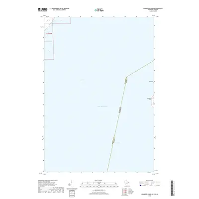
2018 Map of Chambers Island NW
USGS Topo · Published 2018About this map
Chambers Island sits at the eastern edge of this maritime-focused survey, where the northwestern shoreline near Sand Point meets the open waters of Lake Michigan. Most of the area is defined by the vast expanse of Green Bay, an essential waterway for Great Lakes navigation. A significant jurisdictional boundary bisects the waters, marking the line between Michigan and Wisconsin, as well as the divide between Menominee and Door counties. The map provides a detailed view of the offshore landscape during the late 2010s, illustrating the submerged geography and political borders that define this northern stretch of the bay.
Find a feature on this map
12 named features on this map. Tap any name to fly to it.
Don’t see what you’re looking for? This feature index may not catch every label — zoom into the map to look around manually.
Map Details
Editions of this 2018 Chambers Island NW Map
This is the sole edition of this map. No revisions or reprints were ever made.
Other maps of this area

1939 · Marinette
USGS Topo · 1:48,000

1949 · Stephenson
USGS Topo · 1:48,000

1954 · Escanaba
USGS Topo · 1:250,000

1957 · Escanaba
USGS Topo · 1:250,000

1958 · Escanaba
USGS Topo · 1:250,000

1961 · Chambers Island
USGS Topo · 1:62,500

1963 · Cedar River
USGS Topo · 1:62,500
1963 · Birch Creek
USGS Topo · 1:24,000
1963 · Marinette East
USGS Topo · 1:24,000

1963 · Stephenson
USGS Topo · 1:62,500