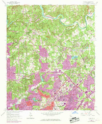
1954 Map of Chamblee
USGS Topo · Published 1969About this map
The Chattahoochee River forms the northwestern boundary of this mid-century landscape, a region transitioning from rural DeKalb and Fulton counties into the expanding northern suburbs of Atlanta. While northern sections around Dunwoody maintain a sparse network of roads like Old Lawrenceville Road, the southern half shows intense post-war development. This growth is centered on industrial and military hubs, notably the U S Naval Reservation Atlanta Air Station and the manufacturing corridor along the Southern Railway in Chamblee and Doraville. Local heritage is anchored by a density of country churches and schools, such as Sharon Ch and Oglethorpe Univ, alongside family landmarks like Holcomb Bridge. The map captures the early footprint of modern infrastructure, with the DeKalb County Water Works Settling Basin and numerous schools like Lynwood Park Sch serving the burgeoning communities.
Find a feature on this map
70 named features on this map. Tap any name to fly to it.
Don’t see what you’re looking for? This feature index may not catch every label — zoom into the map to look around manually.
Map Details
Editions of this 1954 Chamblee Map
5 editions found
Other maps of this area

1888 · Atlanta
USGS Topo · 1:125,000

1890 · Suwanee
USGS Topo · 1:125,000

1890 · Atlanta
USGS Topo · 1:125,000

1892 · Atlanta
USGS Topo · 1:125,000

1894 · Suwanee
USGS Topo · 1:125,000

1895 · Atlanta
USGS Topo · 1:125,000

1953 · Atlanta
USGS Topo · 1:250,000

1954 · Chamblee
USGS Topo · 1:24,000

1954 · Decatur
USGS Topo · 1:24,000

1954 · Bolton
USGS Topo · 1:24,000