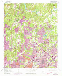
1954 Map of Chamblee
USGS Topo · Published 1974About this map
The Chattahoochee River defines the northern edge of this landscape, where the Morgan Falls Dam and its adjacent substation once anchored the local utility infrastructure. By the mid-20th century, the northward expansion of Atlanta is clearly visible as residential developments and infrastructure projects reach toward Sandy Springs and Dunwoody. The transition from rural farmland to suburban hub is marked by the presence of institutions like Oglethorpe Univ and the sprawling De Kalb-Peachtree Airport.
Find a feature on this map
52 named features on this map. Tap any name to fly to it.
Don’t see what you’re looking for? This feature index may not catch every label — zoom into the map to look around manually.
Map Details
Editions of this 1954 Chamblee Map
5 editions found
Other maps of this area

1888 · Atlanta
USGS Topo · 1:125,000

1890 · Suwanee
USGS Topo · 1:125,000

1890 · Atlanta
USGS Topo · 1:125,000

1892 · Atlanta
USGS Topo · 1:125,000

1894 · Suwanee
USGS Topo · 1:125,000

1895 · Atlanta
USGS Topo · 1:125,000

1953 · Atlanta
USGS Topo · 1:250,000

1954 · Chamblee
USGS Topo · 1:24,000

1954 · Decatur
USGS Topo · 1:24,000

1954 · Bolton
USGS Topo · 1:24,000