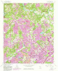
1954 Map of Chamblee
USGS Topo · Published 1983About this map
Chattahoochee River frontage and the expanding northern suburbs of Atlanta define this landscape, as it transitioned from rural outskirts to a major metropolitan hub. The De Kalb-Peachtree Airport and the corridor of the Southern RR serve as the industrial and transportation spine for Chamblee and Doraville. Purple tinting on the map reveals the rapid urban extension into formerly wooded areas during the early 1980s, overprinting the original 1954 survey. Local social foundations are visible through numerous small landmarks like Sharon Ch, Ebenezer Ch, and the Lynwood Park Sch. The northern reach is anchored by the Morgan Falls Dam and the Chattahoochee River National Recreation Area, while the central areas feature community hubs such as Murphy Candler Park and Oglethorpe Univ.
Find a feature on this map
52 named features on this map. Tap any name to fly to it.
Don’t see what you’re looking for? This feature index may not catch every label — zoom into the map to look around manually.
Map Details
Editions of this 1954 Chamblee Map
5 editions found
Other maps of this area

1888 · Atlanta
USGS Topo · 1:125,000

1890 · Suwanee
USGS Topo · 1:125,000

1890 · Atlanta
USGS Topo · 1:125,000

1892 · Atlanta
USGS Topo · 1:125,000

1894 · Suwanee
USGS Topo · 1:125,000

1895 · Atlanta
USGS Topo · 1:125,000

1953 · Atlanta
USGS Topo · 1:250,000

1954 · Chamblee
USGS Topo · 1:24,000

1954 · Decatur
USGS Topo · 1:24,000

1954 · Bolton
USGS Topo · 1:24,000