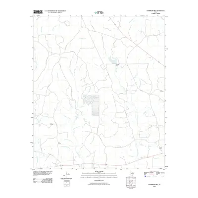
2010 Map of Chambliss Hill
USGS Topo · Published 2010About this map
Big Cypress Creek and its many tributaries, including Horsepen Creek and Fall Branch, define this pocket of Polk County. The landscape is marked by a network of rural roads such as Pure Oil Rd and Old Livingston Rd, reflecting the area's history of petroleum exploration and early regional travel routes. For genealogists, the map preserves the locations of George Cemetery, Hubert Cemetery, and Shiloh Cemetery, along with family-named infrastructure like Crawford Cemetary Rd and Hubert Cemetery Rd. Cultural and recreational sites are represented by Camp Niwana in the southeast and the Jeko Lake Dam, which regulates one of the few significant standing water bodies in this densely wooded creek system. The numerous "branches" and "creeks" named throughout the quadrant, such as Sawmill Branch and Pigpen Branch, suggest a past tied to timber and local agriculture.
Find a feature on this map
48 named features on this map. Tap any name to fly to it.
Don’t see what you’re looking for? This feature index may not catch every label — zoom into the map to look around manually.
Map Details
Editions of this 2010 Chambliss Hill Map
This is the sole edition of this map. No revisions or reprints were ever made.
Other maps of this area

1954 · Beaumont
USGS Topo · 1:250,000

1955 · Woodville
USGS Topo · 1:62,500

1955 · Camden
USGS Topo · 1:62,500

1957 · Beaumont
USGS Topo · 1:250,000

1958 · Segno
USGS Topo · 1:62,500

1958 · Warren
USGS Topo · 1:62,500

1984 · Hortense
USGS Topo · 1:24,000
1984 · Chester
USGS Topo · 1:24,000

1984 · Beaumont
USGS Topo · 1:250,000

1984 · Jacks Creek North
USGS Topo · 1:24,000