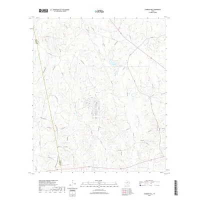
2019 Map of Chambliss Hill
USGS Topo · Published 2019About this map
Hubert Cemetery and the family burial grounds of Hubert Cem, George Cem, and Shiloh Cem anchor the social geography of this timbered landscape along the Polk and Tyler county line. The terrain is defined by an intricate network of watercourses, including Big Cypress Cr and Horsepen Cr, which drain into the surrounding lowlands. Notable landmarks such as Hubert Springs and Camp Nita Spring indicate the importance of natural water sources to the local area. Evidence of the region's rural industry persists in labels like Sawmill Br, while the topographic prominence of White Tail Ridge and the man-made Jeko Lake characterize the physical environment. A maze of county roads and historic routes like Old CC Rd connects these scattered points of interest, providing a detailed view of the rural infrastructure as it exists in the modern era.
Find a feature on this map
66 named features on this map. Tap any name to fly to it.
Don’t see what you’re looking for? This feature index may not catch every label — zoom into the map to look around manually.
Map Details
Editions of this 2019 Chambliss Hill Map
This is the sole edition of this map. No revisions or reprints were ever made.
Other maps of this area

1954 · Beaumont
USGS Topo · 1:250,000

1955 · Woodville
USGS Topo · 1:62,500

1955 · Camden
USGS Topo · 1:62,500

1957 · Beaumont
USGS Topo · 1:250,000

1958 · Segno
USGS Topo · 1:62,500

1958 · Warren
USGS Topo · 1:62,500

1984 · Hortense
USGS Topo · 1:24,000
1984 · Chester
USGS Topo · 1:24,000

1984 · Beaumont
USGS Topo · 1:250,000

1984 · Jacks Creek North
USGS Topo · 1:24,000