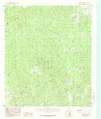
1984 Map of Chambliss Hill
USGS Topo · Published 1984About this map
Chambliss Hill and Horsepen Hill rise above a densely dissected landscape along the boundary shared by Polk and Tyler Counties. This 1984 provisional survey illustrates a terrain defined by an intricate network of drainage, where major watercourses like Big Creek and Big Cypress Creek are fed by numerous family-named or descriptively named tributaries. The nomenclature of the area—ranging from Sawmill Branch and Pigpen Branch to Wolfpen Creek—suggests a history rooted in small-scale timber operations and livestock husbandry. The absence of major settlements emphasizes the rural character of the Big Thicket region, where the primary human footprint is found in the scattered road network and the Indefinite Boundary marking the county line. Notable minor landmarks such as Hubert Spring Branch and Treasure Branch provide specific points of interest for local historians and researchers tracing the geography of the East Texas woods during the late twentieth century.
Find a feature on this map
27 named features on this map. Tap any name to fly to it.
Don’t see what you’re looking for? This feature index may not catch every label — zoom into the map to look around manually.
Map Details
Editions of this 1984 Chambliss Hill Map
This is the sole edition of this map. No revisions or reprints were ever made.
Other maps of this area

1954 · Beaumont
USGS Topo · 1:250,000

1955 · Woodville
USGS Topo · 1:62,500

1955 · Camden
USGS Topo · 1:62,500

1957 · Beaumont
USGS Topo · 1:250,000

1958 · Segno
USGS Topo · 1:62,500

1958 · Warren
USGS Topo · 1:62,500

1984 · Hortense
USGS Topo · 1:24,000
1984 · Chester
USGS Topo · 1:24,000

1984 · Beaumont
USGS Topo · 1:250,000

1984 · Jacks Creek North
USGS Topo · 1:24,000