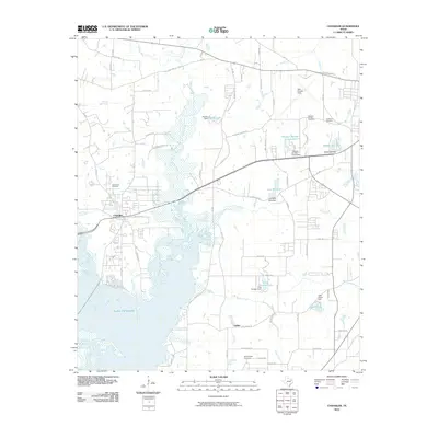
2010 Map of Chandler
USGS Topo · Published 2010About this map
Lake Palestine dominates the southwestern portion of this landscape, its waters meeting the Neches River and Prairie Creek to the north. The town of Chandler sits at a crossroads of growth, where the Old Tyler Rd and Old Chandler Hwy intersect. The map documents a transition toward residential development with areas like Pleasant Retreat Acres, yet maintains deep ties to local heritage through a concentration of family and community burial grounds. Genealogists will find the locations of Macedonia Cemetery, Sevenleague Cemetery, Hudson J Cemetery, and Pleasant Retreat Cemetery clearly marked. To the east, the edge of Tyler Pounds Field indicates the proximity of regional infrastructure. The terrain is characterized by a series of small, dammed water bodies, including Peveto Lake, Lost Pine Lake, and Lake Placid, reflecting the importance of water management in the Smith County countryside.
Find a feature on this map
70 named features on this map. Tap any name to fly to it.
Don’t see what you’re looking for? This feature index may not catch every label — zoom into the map to look around manually.
Map Details
Editions of this 2010 Chandler Map
This is the sole edition of this map. No revisions or reprints were ever made.
Other maps of this area

1946 · Bullard
USGS Topo · 1:62,500

1948 · Bullard
USGS Topo · 1:62,500

1948 · Tyler
USGS Topo · 1:62,500

1948 · Brownsboro
USGS Topo · 1:62,500

1949 · Tyler
USGS Topo · 1:62,500

1949 · Brownsboro
USGS Topo · 1:62,500

1949 · Frankston
USGS Topo · 1:62,500

1950 · Frankston
USGS Topo · 1:62,500

1956 · Tyler
USGS Topo · 1:250,000

1966 · Chandler
USGS Topo · 1:24,000