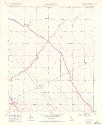
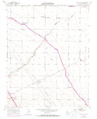
1955 Map of Chaney Ranch
USGS Topo · Published 1972About this map
Chaney Ranch and several neighboring agricultural operations anchor this Central Valley landscape in the mid-1950s, a period when local ranching was increasingly intersected by major state infrastructure projects. The path of Panoche Creek winds through the terrain, while the later addition of the California Aqueduct—marked by 1971 revisions—slashes diagonally across the acreage, reflecting the shifting water management of Fresno County. The Presence of the Silver Creek Church and the Fairfax Gin indicates a community built around both faith and cotton processing. Other family-named holdings like Gramis Ranch, Pilibos Ranch, and La Jolla Ranch dot the grid of section lines, showing the scale of land ownership during this era. Scattered utilities such as Panoche Substation and Hammonds Substation provide the electrical backbone for the industrial-scale farming and the Storage Bin facilities that characterize the local economy.
Find a feature on this map
23 named features on this map. Tap any name to fly to it.
Don’t see what you’re looking for? This feature index may not catch every label — zoom into the map to look around manually.
Map Details
Editions of this 1955 Chaney Ranch Map
5 editions found
Other maps of this area

1913 · Panoche
USGS Topo · 1:125,000

1921 · Tierra Loma School
USGS Topo · 1:31,680

1922 · Tufts Ranch
USGS Topo · 1:31,680

1922 · Chaney Ranch
USGS Topo · 1:31,680

1923 · Levis
USGS Topo · 1:31,680

1923 · Wisdom Well
USGS Topo · 1:31,680

1923 · Firebaugh
USGS Topo · 1:31,680

1923 · Tierra Loma School
USGS Topo · 1:31,680

1923 · Little Panoche
USGS Topo · 1:31,680

1923 · Monocline Ridge
USGS Topo · 1:31,680