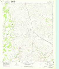
1958 Map of Chapin
USGS Topo · Published 1979About this map
The boundary between Parker Co and Hood Co divides this landscape, where the rural settlements of Chapin and Baker anchor a region of creeks and ranchlands. The terrain is defined by the headwaters of Long Creek and Rucker Creek, with the Old Railroad Grade and an extensive Telephone Cable and Pipeline network marking the infrastructure of the mid-20th century.
Find a feature on this map
25 named features on this map. Tap any name to fly to it.
Don’t see what you’re looking for? This feature index may not catch every label — zoom into the map to look around manually.
Map Details
Editions of this 1958 Chapin Map
Other maps of this area

1889 · Granbury
USGS Topo · 1:125,000

1891 · Weatherford
USGS Topo · 1:125,000

1893 · Weatherford
USGS Topo · 1:125,000

1923 · Granbury 2-a
USGS Topo · 1:48,000

1923 · Granbury 1-b
USGS Topo · 1:48,000

1924 · Weatherford 3-d
USGS Topo · 1:48,000

1928 · Godley
USGS Topo · 1:62,500

1931 · Dennis
USGS Topo · 1:62,500

1931 · Tolar
USGS Topo · 1:62,500

1954 · Dallas
USGS Topo · 1:250,000