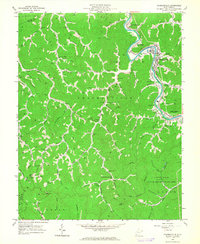
1963 Map of Chapmanville
USGS Topo · Published 1964About this map
The Guyandotte River winds through the heart of Logan County in the early 1960s, serving as a corridor for both industry and community life. The Chesapeake and Ohio railroad parallels the riverbank, connecting coal-reliant settlements like Stone Branch and Phico to the broader regional economy. While Chapmanville serves as a primary hub, the landscape is defined by its hollows and ridges, where family life is rooted near places like Morning Star Ch and numerous small cemeteries such as Campbell Cem and Lily Cem.
Find a feature on this map
96 named features on this map. Tap any name to fly to it.
Don’t see what you’re looking for? This feature index may not catch every label — zoom into the map to look around manually.
Map Details
Editions of this 1963 Chapmanville Map
3 editions found
Other maps of this area

1887 · Warfield
USGS Topo · 1:125,000

1891 · Oceana
USGS Topo · 1:125,000

1891 · Warfield
USGS Topo · 1:125,000

1892 · Huntington
USGS Topo · 1:125,000

1893 · Oceana
USGS Topo · 1:125,000

1898 · Huntington
USGS Topo · 1:125,000

1898 · Oceana
USGS Topo · 1:125,000

1899 · Charleston
USGS Topo · 1:125,000

1902 · Midkiff
USGS Topo · 1:62,500

1907 · Midkiff
USGS Topo · 1:62,500