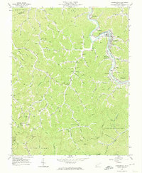
1963 Map of Chapmanville
USGS Topo · Published 1974About this map
The Guyandotte River carves a deep path through this Logan County landscape, where mid-century industrial infrastructure meets established valley settlements. The river bend at Chapmanville serves as the primary hub, anchored by the Chesapeake and Ohio railroad and a mix of modern amenities like the Drive-in Theater and County Country Club. Moving away from the river, the terrain is defined by an intricate network of hollows and forks, such as Smokehouse Fork and Bearwallow Branch, which are dotted with family-named cemeteries and small community institutions. Numerous Gas Well and Oil Well symbols, along with several pipelines, reveal the area's extraction-based economy. To the southeast, the nascent Chief Logan State Recreation Area begins to occupy the rugged hillsides. Genealogists can locate specific family burial grounds like Barker Cem, Vance Cem, and Fillinger Cem, while local historians can trace rural school locations including Dingess Sch and White Oak Sch.
Find a feature on this map
99 named features on this map. Tap any name to fly to it.
Don’t see what you’re looking for? This feature index may not catch every label — zoom into the map to look around manually.
Map Details
Editions of this 1963 Chapmanville Map
3 editions found
Other maps of this area

1887 · Warfield
USGS Topo · 1:125,000

1891 · Oceana
USGS Topo · 1:125,000

1891 · Warfield
USGS Topo · 1:125,000

1892 · Huntington
USGS Topo · 1:125,000

1893 · Oceana
USGS Topo · 1:125,000

1898 · Huntington
USGS Topo · 1:125,000

1898 · Oceana
USGS Topo · 1:125,000

1899 · Charleston
USGS Topo · 1:125,000

1902 · Midkiff
USGS Topo · 1:62,500

1907 · Midkiff
USGS Topo · 1:62,500